Not to be missed…
On the Peninsula
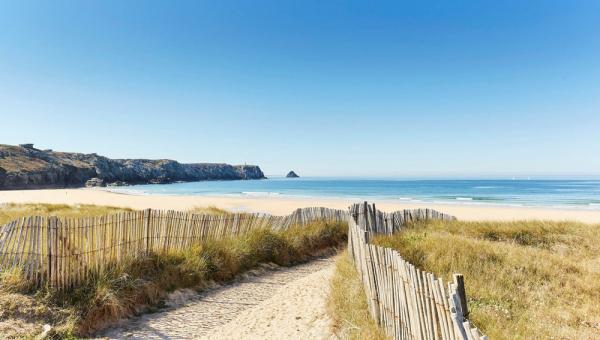
Wherever the wind blows...
there is always a sheltered beach for you
From the tiny cove accessible only by sea to the vast sandy expanse with parking and bistros nearby, you will find all kinds of beaches on the Crozon peninsula.
Along our 120 km coastline, there are multiple beaches and small pebble beaches, but all the beaches listed below are beaches of beautiful fine sand, ideal for sandcastles and sunbathing!

Trez Rouz

La Palue
Large beach next to Lostmarc'h beach, a popular spot for certain water sports, facing west and the Tas de Pois. Swimming is strictly prohibited.
Pen Had
Facing west, Pen Had beach, the wildest in Camaret, is the place to be for lovers of space and sea spray, with its gentle slopes dotted with dunes and a breathtaking view of the Lion Rock and the Toulinguet point.
Please note, swimming is strictly prohibited. (presence of rip currents and strong currents).

Kerloc'h
Located along the departmental road, the Kerloc'h beach on the Crozon peninsula is the most easily accessible beach of theDinan coveThe beach is mostly used by bathers at low tide and when the sea is calm (when the sea is rough it is mostly surfers who come to this beach). Very pleasant beach.

Lostmac'h
Large west-facing beach exposed to winds and sea spray, overlooked by the Lostmarc'h menhir and the barred spur, an ancient fortification.
Please note, swimming is strictly prohibited.

Goulien

Kersiguenou
Kersiguénou Beach, 800 meters long, is located between Kerloc'h Beach and Goulien Beach, which merge at low tide. Swimming is not supervised.

The Kador
Small, fine sandy beach in Douarnenez Bay, bordered by a rocky outcrop and an arch. In good weather, you can see the Menez-Hom River opposite. Unsupervised swimming.

The Aber
A unique beach located in Douarnenez Bay, including an islet accessible on foot at low tide (pay attention to tide times). 1250m long, south-facing family beach.
The Portzik
Located in the commune of Morgat, Portzic Beach, sheltered from the wind, stretches its fine sand over 400 meters into Douarnenez Bay. Unsupervised swimming is available.

Veyriac'h

Morgat
The beach is accessible to people with reduced mobility thanks to its access ramp. The municipality and the port team provide swimming aids.
Magnificent walks on the GR34
The customs path, which runs along the 120 km of coastline of the Crozon Peninsula, offers marvelous panoramas and exceptional heritage sites at every turn. And why not treat yourself to a swim at one of the beaches you come across?

The Capuchin Fort

The Battle of the Atlantic Museum
The Atlantic Battle Memorial Museum was built in one of the blockhouses on the Kerbonn cliff, 50 m above the sea.
As you head towards the tip of Pen Hir, you will see from afar the gigantic anchors that mark the Memorial Museum dedicated to the Battle of the Atlantic and which pays tribute to all the sailors, both civilian and military, who lost their lives at sea during this crucial episode of the Second World War.

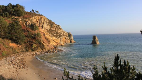
The castle of the Pointe de Dinan
Don't look for the drawbridge or the turrets! Thiscastledoes not need it... This is the name of this enormous rock connected to the point by an arch dug by the sea, which can be seen very well from theKerloc'h beach, on the other side of Dinan cove, at each low tide.

The tip of Toulinguet
The Toulinguet point is the most exposed point of the Crozon peninsula.
It is pierced by several caves, more or less deep, which are revealed on days of high tide.
It is a military site that can be visited during Heritage Days. There you will see numerous fortifications, a very pretty little lighthouse (1848) and a semaphore (1952) still in operation.

Virgin Island
Île Vierge, another name for the point of Saint-Hernot (pronounced Saint-Hernotte), is in reality a very small peninsula, on the east coast of Cap de la Chèvre…
It is located on the coastal path that leads from Morgat to Cap de la Chèvre. As long as the sun is high enough to illuminate the light sandy bottom and give the water this pretty turquoise color, it is impossible to miss the photo of this magnificent landscape. Due to the difficulty of access and the risk of landslides and… its overcrowding, its beach is now prohibited from access, but from the path, the view is striking!

The Goat Cape
The west coast, very exposed, is made up of cliffs covered with moors and long sandy beaches (Lostmarc'h, La Palue and Kerdreux), famous among surfers but prohibited for swimming.
To the east, the maritime pines have grown so well on the cliffs that they give the coast a hint of the Mediterranean...

The small port of Fret
Le Fret is, by its size, a very small port on the harbor of Brest...
Right next to the village, there is a tidal pond (above): it fills and empties partly with each tide. It is very rich in fish, as evidenced by the many bird species that frequent it. It is a protected area; a path will allow you to walk along part of it (but without your dog!).
This pond is separated from the harbor of Brest by a dike road.
The beach bordering this road (below) is very popular for fishing on foot on days of high tide.

The tip of Kador in Morgat
The Kador peak protects Morgat from the assaults of major winter storms.
A very, very, very long time ago, the tip of Kador was a massive rocky spur that jutted out into the sea.
One stormy day, some fishermen found themselves stranded, just on the other side.
Fortunately, Saint Marine was watching! Breaking through the rock to allow the men to reach the small beach of Kador was child's play for her.
Over time, repeated assaults by waves and wind enlarged the hole, until it became a beautiful arch, which collapsed relatively recently (April 1983).